
Landscape Photography

Grand Traverse Bay West Arm Marinas from NW - Summer 2021
This aerial photo along Grand Traverse Bay was taken on a summer morning in July 2021 from north of the marinas facing southeast towards Traverse City.

This aerial photo along Grand Traverse Bay was taken on a summer morning in July 2021 from north of the marinas facing southeast towards Traverse City.

Bowers Harbor near Traverse City Aerial Photo from NE - 2021
Bowers Harbor is located on Old Mission Peninsula on the West Arm of Grand Traverse Bay, about 10 miles North of Traverse City in Grand Traverse County. This aerial photo was taken northeast of the harbor on a summer day in 2021.

Bowers Harbor is located on Old Mission Peninsula on the West Arm of Grand Traverse Bay, about 10 miles North of Traverse City in Grand Traverse County. This aerial photo was taken northeast of the harbor on a summer day in 2021.
Prints are available to purchase by clicking the on the image above or by visiting lakes-of-michigan.com.

Mission Point Lighthouse near Traverse City Aerial Photo from North - 2021
This is an aerial photo of the Mission Point Lighthouse near Traverse City taken on a summer day in 2021.

This is an aerial photo of the Mission Point Lighthouse near Traverse City taken on a summer day in 2021.
Prints are available to purchase by clicking the on the image above or by visiting lakes-of-michigan.com.

Traverse City Aerial Photo from Northwest
This aerial photo of Traverse City was taken from northwest of the city over the waters of the West Arm of the Grand Traverse Bay on a sunny afternoon.

This aerial photo of Traverse City was taken from northwest of the city over the waters of the West Arm of the Grand Traverse Bay on a sunny afternoon.
Prints are available to purchase by clicking the on the image above or by visiting lakes-of-michigan.com.

Torch Lake near Bellaire Aerial Photo from South 2020
Torch Lake is located near Bellaire, Central Lake, Alden, Rapid City, Eastport, Kewadin, and Rapid City, about 15 miles northeast of Traverse City in Antrim County in Michigan's lower peninsula. This photo was taken at the south end of the 17 mile-long lake on a summer day. The south end of Torch Lake is famous for its shallow sand bar area that is typically packed with boaters and swimmers on sunny summer days. In the lower right corner we can see where the south end of Torch Lake connects to the torch river, which extends 2 miles south to Lake Skegemog.

Torch Lake is located near Bellaire, Central Lake, Alden, Rapid City, Eastport, Kewadin, and Rapid City, about 15 miles northeast of Traverse City in Antrim County in Michigan's lower peninsula. This photo was taken at the south end of the 17 mile-long lake on a summer day. The south end of Torch Lake is famous for its shallow sand bar area that is typically packed with boaters and swimmers on sunny summer days. In the lower right corner we can see where the south end of Torch Lake connects to the torch river, which extends 2 miles south to Lake Skegemog.
Prints are available to purchase by clicking the image above or by visiting lakes-of-michigan.com.
Torch Lake near Bellaire Aerial Photo from SE 2019
Torch Lake is located near Bellaire, Central Lake, Alden, Rapid City, Eastport, Kewadin, and Rapid City, about 15 miles NE of Traverse City in Antrim County in Michigan's lower peninsula. This photo was taken SE of the lake on a summer day in 2019.

Torch Lake is located near Bellaire, Central Lake, Alden, Rapid City, Eastport, Kewadin, and Rapid City, about 15 miles NE of Traverse City in Antrim County in Michigan's lower peninsula. This photo was taken SE of the lake on a summer day in 2019.
Prints are available to purchase by clicking the image above or by visiting lakes-of-michigan.com.

Torch Lake near Bellaire Aerial Photo from North 2019
Torch Lake is located near Bellaire, Central Lake, Alden, Rapid City, Eastport, Kewadin, and Rapid City, about 15 miles northeast of Traverse City in Antrim County in Michigan's lower peninsula. This photo was taken north of the lake on a summer day. On the distant right is Grand Traverse Bay.

Torch Lake is located near Bellaire, Central Lake, Alden, Rapid City, Eastport, Kewadin, and Rapid City, about 15 miles northeast of Traverse City in Antrim County in Michigan's lower peninsula. This photo was taken north of the lake on a summer day. On the distant right is Grand Traverse Bay.
Prints are available to purchase by clicking the image above or by visiting lakes-of-michigan.com.

Suttons Bay on the Leelanau Peninsula Aerial Photo from W
Suttons Bay is located on the east side of the Leelanau Peninsula on Grand Traverse Bay, about 16 miles north of Traverse City in Michigan's lower peninsula. This aerial photo was taken from west of the bay on a summer day.

Suttons Bay is located on the east side of the Leelanau Peninsula on Grand Traverse Bay, about 16 miles north of Traverse City in Michigan's lower peninsula. This aerial photo was taken from west of the bay on a summer day.
Prints are available to purchase by clicking the image above or by visiting lakes-of-michigan.com.

Spider Lake near Traverse City Aerial Photo from N
Spider Lake is located about 8 miles southeast of Traverse City in Grand Traverse County in Michigan's lower peninsula. This aerial photo was taken from north of the lake on a summer morning.

Spider Lake is located about 8 miles southeast of Traverse City in Grand Traverse County in Michigan's lower peninsula. This aerial photo was taken from north of the lake on a summer morning.
Prints are available to purchase by clicking the image above or by visiting lakes-of-michigan.com.

Old Mission Harbor near Traverse City from N
Old Mission Harbor is located on the Old Mission Peninsula about 14 miles north of Traverse City within Grand Traverse Bay. This aerial photo was taken on a summer afternoon from north of the harbor facing the East Arm of the Grand Traverse Bay.

Old Mission Harbor is located on the Old Mission Peninsula about 14 miles north of Traverse City within Grand Traverse Bay. This aerial photo was taken on a summer afternoon from north of the harbor facing the East Arm of the Grand Traverse Bay.
Prints are available to purchase by clicking the image above or by visiting lakes-of-michigan.com

Mission Point Lighthouse Aerial Photo near Traverse City
This is an aerial photo of the Mission Point Lighthouse at the tip of the Old Mission Peninsula near Traverse City. This panoramic photo features a view of the width peninsula, with the Lighthouse peeking out through the trees on a summer morning.

This is an aerial photo of the Mission Point Lighthouse at the tip of the Old Mission Peninsula near Traverse City. This panoramic photo features a view of the width peninsula, with the Lighthouse peeking out through the trees on a summer morning.
Prints are available to purchase by clicking the image above or by visiting lakes-of-michigan.com.

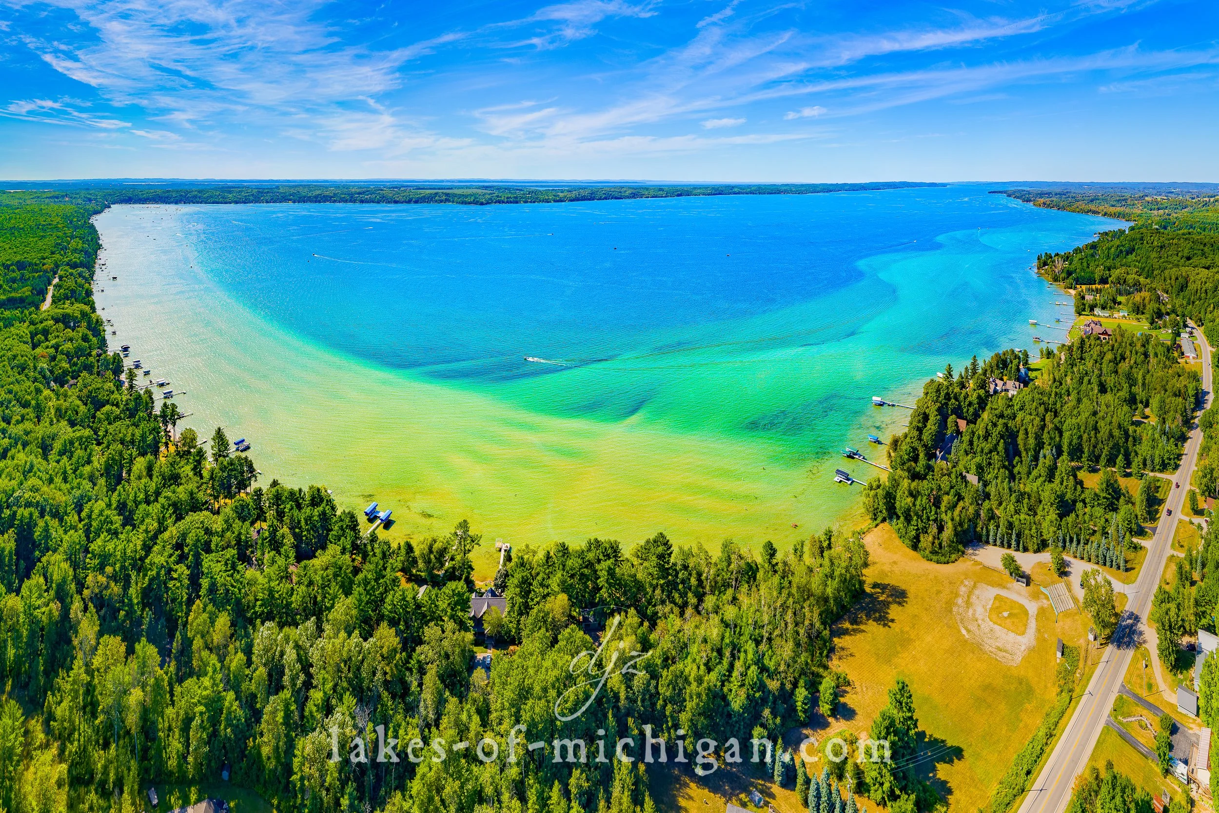
Grand Traverse Bay West Arm Aerial Photo from SW near Traverse City
Grand Traverse Bay is located along the shores of Lake Michigan in the northwest region of Michigan's lower peninsula. Divided into the East and West Arm by the Old Mission Peninsula, Grand Traverse Bay is around 30 miles long and 10 miles wide (give or take). Some of the towns and cities within the bay include Traverse City, Northport, Omena, Peshawbestown, Suttons Bay, Old Mission, and Elk Rapids. This aerial photo was taken from the southwest corner of the West Arm of Grand Traverse bay on a summer afternoon.

Grand Traverse Bay is located along the shores of Lake Michigan in the northwest region of Michigan's lower peninsula. Divided into the East and West Arm by the Old Mission Peninsula, Grand Traverse Bay is around 30 miles long and 10 miles wide (give or take). Some of the towns and cities within the bay include Traverse City, Northport, Omena, Peshawbestown, Suttons Bay, Old Mission, and Elk Rapids. This aerial photo was taken from the southwest corner of the West Arm of Grand Traverse bay on a summer afternoon.
Prints are available to purchase by clicking the image above or by visiting lakes-of-michigan.com.

Cedar Lake near Traverse City Aerial Photo from NW
Cedar Lake is located just a couple miles northwest of Traverse City along the West Arm of Grand Traverse Bay in Leelanau County in Michigan's lower peninsula. This aerial photo was taken from northwest of the lake on a summer day, with the West Arm of Grand Traverse Bay in the background.

Cedar Lake is located just northwest of Traverse City along the West Arm of Grand Traverse Bay in Leelanau County in Michigan's lower peninsula. This aerial photo was taken from northwest of the lake on a summer day.
Prints are available to purchase by clicking the image above or by visiting lakes-of-michigan.com.

Bowers Harbor near Traverse City Aerial Photo from NE
Bowers Harbor is located on Old Mission Peninsula on the West Arm of Grand Traverse Bay, about 10 miles North of Traverse City in Grand Traverse County. This aerial photo was taken northeast of the harbor on a summer day.

Bowers Harbor is located on Old Mission Peninsula on the West Arm of Grand Traverse Bay, about 10 miles North of Traverse City in Grand Traverse County. This aerial photo was taken northeast of the harbor on a summer day.
Prints are available to purchase by clicking the image above or by visiting lakes-of-michigan.com.

Arbutus Lake near Traverse City Aerial Photo from NE
Arbutus Lake is located about 7 miles southeast of Traverse City in Grand Traverse County in Michigan's lower peninsula. This aerial photo was taken from northeast of the lake on a summer morning.

Arbutus Lake is located about 7 miles southeast of Traverse City in Grand Traverse County in Michigan's lower peninsula. This aerial photo was taken from northeast of the lake on a summer morning.
Prints are available to purchase by clicking the image above or by visiting lakes-of-michigan.com.